The southern region of Peru boasts the greatest diversity of landscapes and cultures in the country. From the snow-capped peaks of the Andes to the depths of the Amazon rainforest, passing through coastal deserts and the highest navigable lake in the world, this area offers experiences that transform any traveler’s perspective on what it means to explore authentic Peru.
Main tourist destinations in the south
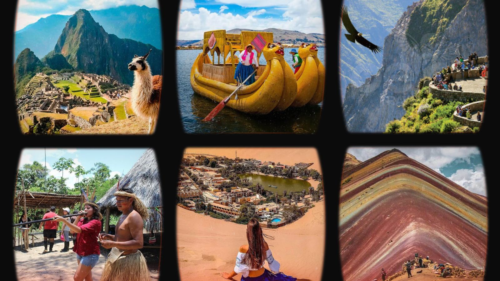
Cusco and Machu Picchu
The ancient capital of the Inca Empire stands at 3,399 meters above sea level, blending pre-Hispanic architecture with colonial buildings in a unique urban setting in Latin America. From here, you’ll access the most impressive network of archaeological sites on the continent.
Main Square (Plaza de Armas) and historic center
The main square of Cusco welcomes you with architecture that narrates five centuries of layered history. The polished stone walls of the Incas serve as foundations for baroque churches and colonial mansions that surround the cobblestone plaza. The Cathedral, built on the palace of the Inca Viracocha, houses over 400 canvases from the Cusco school of painting, including the famous depiction of the Last Supper featuring guinea pig as the main dish.
You’ll walk along cobblestone streets where every corner reveals perfectly assembled Inca walls without mortar. Hatunrumiyoc Street showcases the twelve-angled stone, an extraordinary example of Inca architectural precision. The carved wooden balconies of colonial houses contrast with the sobriety of pre-Hispanic walls, creating an irreplaceable urban landscape.
The San Pedro and San Blas markets operate from 5:00 AM, offering Andean products like quinoa, kiwicha, and native potatoes in over 50 varieties. Here, you can taste juices made from Amazonian fruits like camu camu and aguaymanto while observing the commercial exchange that keeps ancestral traditions of barter alive.

Sacred Valley of the Incas
The Vilcanota River winds through this valley at an altitude of 2,800 meters, creating a microclimate that allowed the Incas to develop the most sophisticated agriculture in pre-Columbian America. The agricultural terraces of Pisac stretch across the mountainsides like giant steps, demonstrating irrigation techniques that continue to function after 500 years.
In Ollantaytambo, you’ll discover the only Inca city that has been continuously inhabited. Its stone streets maintain the original drainage system, while current houses are built on pre-Hispanic foundations. The Ollantaytambo fortress features granite blocks weighing up to 50 tons transported from quarries located 8 kilometers away, showcasing the logistical capabilities of the Inca Empire.
The Sunday markets in Pisac gather farming communities from across the region. You’ll find textiles crafted using ancestral techniques, ceramics reproducing pre-Inca designs, and Andean musical instruments. The locals wear traditional clothing not for tourists, but as part of their everyday cultural identity.

Citadel of Machu Picchu
The lost city of the Incas gradually reveals itself as the train zigzags through the Urubamba River canyon. Built in 1450 AD on a granite mountain at an altitude of 2,430 meters, Machu Picchu represents the perfect synthesis of architecture and natural landscape.
Early entry at 6:00 AM allows you to experience the sunrise from the Guardian’s House, watching as the first rays of sunlight illuminate the agricultural terraces while the mist slowly dissipates. The Temple of the Sun features astronomically oriented windows to mark the solstices, demonstrating the scientific knowledge of its builders.
The climb to Huayna Picchu requires prior reservation and good physical condition to ascend 400 meters along original Inca trails. From the summit, Machu Picchu can be appreciated in all its magnitude, showcasing urban planning that integrates 200 structures distributed across agricultural, urban, and religious sectors.
The Temple of the Three Windows symbolizes the three worlds of Andean cosmology, while the Intihuatana stone functions as a sundial and astronomical calendar. Each structure reveals aspects of a civilization that reached levels of sophistication comparable to the great cultures of the ancient world.
Rainbow Mountain
Vinicunca, known as Rainbow Mountain, presents mineral strata that create natural color bands at an altitude of 5,200 meters. The 3-hour hike from Pitumarca takes you through high Andean landscapes where alpacas and llamas graze on prairies stretching to the horizon.
The reddish colors come from iron oxides, yellows from ferric sulfide, and greens from magnesium and iron minerals. This geological phenomenon, recently revealed by glacial melting, attracts photographs from different angles along the route.
The extreme altitude requires acclimatization in Cusco for at least two days. Bring warm clothing, as temperatures can drop below zero even during the day. Some operators offer horses for the final stretch of the ascent, reducing the physical effort required.

Arequipa and the Colca Valley
The “White City” built with volcanic sillar rises at 2,335 meters in a valley surrounded by three volcanoes: Misti, Chachani, and Pichu Pichu. Its colonial historic center, declared a UNESCO World Heritage Site, preserves the best-conserved viceroyal architecture in Peru.
Main Square (Plaza de Armas) and Santa Catalina Monastery
The main square of Arequipa features homogeneous architecture made of white sillar that reflects sunlight, creating a uniquely bright atmosphere in Peru. The Cathedral occupies an entire side of the square with its neoclassical façade and towers that stand out against the Misti volcano. Its 19th-century European organs and the pulpit carved from French wood represent exceptional colonial artistic treasures.
The Santa Catalina Monastery, founded in 1579, operates as a city within a city. Its 20,000 square meters include cobblestone streets, inner plazas, and cells that recreate convent life over four centuries. The cloistered nuns lived here as if in small private residences, with servants and slaves attending to their daily needs.
You’ll walk along Toledo Street, painted indigo blue, and Sevilla Street, in colonial ochre, while observing ovens, laundry, and dining halls that maintain their original functionality. The main cells include bedrooms, living rooms, and private patios that demonstrate the economic level of the families who sent their daughters to the convent.
Yanahuara viewpoints and volcanoes
The Yanahuara district offers the most photogenic perspective of Arequipa with its guardian volcanoes. Its cobblestone streets and sillar houses maintain a village atmosphere within the modern metropolis. The viewpoint features sillar arches framing the Misti volcano, which rises 5,822 meters directly behind the city.
The traditional picanterías of Yanahuara serve Arequipeña specialties like stuffed rocoto, shrimp chupe, and Arequipeño adobo in settings that preserve colonial architecture. The inner patios with corridors and central gardens recreate domestic life from the viceroyal period.
The Misti volcano presents a perfect conical shape with a crater visible from the city. Its ascent takes two days of technical trekking, while Chachani (6,057 meters) offers a more accessible route for experienced mountaineers. From urban viewpoints, you can plan approach routes while observing the different faces of these Andean giants.
Colca Canyon and condor watching
The world’s deepest canyon reaches 4,160 meters from the edge to the river, doubling the depth of the Grand Canyon in Colorado. The journey from Arequipa crosses the Salinas and Aguada Blanca National Reserve, where vicuñas, alpacas, and Andean flamingos inhabit volcanic landscapes at over 4,000 meters altitude.
The valley’s towns maintain pre-Inca agricultural traditions on terraces that transform arid slopes into tiered green fields. Chivay, the provincial capital, features natural hot springs where you can relax after traveling through mountain roads.
The viewpoint at Cruz del Cóndor serves as a natural theater to observe the flight of these Andean giants. The condors take advantage of the morning thermal currents to soar from the canyon floor to heights exceeding 3,000 meters. Their wingspan of up to 3.2 meters allows them to glide for hours without flapping their wings.
The best observation occurs between 8:00 and 10:00 AM, when the rising air currents enable efficient flight. On some days, you can see up to 15 condors simultaneously, including juveniles practicing flying techniques under the supervision of adults.

Puno and Lake Titicaca
The highest navigable lake in the world extends at 3,812 meters altitude between Peru and Bolivia, covering 8,300 square kilometers of blue waters that reflect the snow-capped peaks of the mountain range. The lake cultures have developed unique ways of life adapted to the extreme conditions of the high plateau.
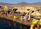
Floating islands of the Uros
The Uros build artificial islands using totora, a water plant that grows along the shores of the lake. These constantly renewed floating islands house entire families that maintain traditions over 500 years old. You’ll walk on spongy surfaces formed by layers of dry totora that gently sway with the movement of the water.
The houses, also built with totora, include solar panels that power radios and televisions, demonstrating how ancestral traditions adapt to modern technology. The inhabitants fish, hunt waterfowl, and craft handicrafts to sell to visitors.
The traditional totora boats maintain pre-Columbian designs with bows shaped like a puma’s head. These rafts can carry up to eight people and navigate efficiently through the lake’s waters, taking advantage of the buoyancy and flexibility of totora.
Taquile and Amantaní
Taquile Island preserves textile traditions recognized by UNESCO as Intangible Cultural Heritage of Humanity. Men weave chullos (hats) whose design and colors indicate their marital and social status, while women create belts and shawls using techniques passed down through generations.
The walk along cobblestone paths of Inca origin connects agricultural terraces where they grow potatoes, quinoa, and beans adapted to the extreme altitude. There are no motorized vehicles on the island, and the community is organized through rotating charge systems that maintain social cohesion.
Amantaní, known as the “Island of Love,” features two ceremonial temples at its highest points: Pachatata (Father Earth) and Pachamama (Mother Earth). Local families host guests in their homes, sharing traditional meals and daily activities like sheep herding and wool spinning.
Culture and traditions at altitude
The city of Puno serves as the folkloric capital of Peru, celebrating over 350 traditional dances throughout the year. The Festival of the Virgin of Candelaria in February transforms the streets into stages where thousands of dancers perform choreographies that narrate Andean myths and historical episodes.
The costumes for the various dances require months of preparation and significant investments from participating families. The embroidery includes threads of gold and silver, while the masks carved in plaster represent mythological characters like devils, angels, and sacred animals.
The Bellavista market functions as a commercial exchange center between the high plateau and the jungle, offering products like charqui (dried meat), chuño (dehydrated potato), and coca along with Amazonian fruits transported from the eastern valleys. This commercial exchange maintains economic connections that existed since pre-Inca times.

Paracas and the Ballestas Islands
The Paracas Peninsula protects unique coastal ecosystems where the desert meets the Pacific Ocean. The cold waters of the Humboldt Current create ideal conditions for exceptional marine biodiversity that supports millions of seabirds.
Paracas National Reserve
This reserve protects 335,000 hectares of marine-coastal ecosystems where flamingos, pelicans, and Humboldt penguins coexist in a unique desert landscape. The red sand beaches contrast with rocky cliffs sculpted by millennia of marine erosion.
The Paracas Cathedral, a natural rock formation in the shape of an arch, collapsed during the earthquake of 2007, but other attractions like Red Beach maintain their scenic beauty. The reddish color comes from volcanic sediments and crushed shells that create changing hues depending on sunlight.
The constant winds of Paracas reach speeds over 30 kilometers per hour, creating ideal conditions for sports like kitesurfing and windsurfing. The mobile dunes constantly advance, burying and revealing archaeological sites of the Paracas and Nazca cultures.
Marine wildlife watching
The Ballestas Islands house the largest concentration of marine life in Peru. South American sea lions form colonies of up to 8,000 individuals on rocky beaches where cormorants, blue-footed boobies, and shearwaters also nest. The speedboat tour lasts 2 hours and allows you to observe this wildlife from distances that do not disturb their natural behavior.
The Humboldt penguins, an endemic species of the Peruvian marine current, build nests in caves and rocky crevices. These penguins can dive up to 150 meters deep in pursuit of anchovies, their main food source. During certain months, you can observe juveniles learning fishing techniques under the supervision of adults.
The surrounding waters occasionally welcome visits from bottlenose dolphins and humpback whales during their seasonal migrations. The dolphins often accompany boats, jumping in the wakes while showcasing their aquatic agility.

Nazca Lines and the Candelabra
The Candelabra of Paracas, a geoglyph 180 meters long etched into the hillside, remains visible from the sea several kilometers away. Its origin and meaning generate academic debates, but its strategic location suggests navigation functions for pre-Columbian cultures.
The proximity to the Nazca Lines (2 hours by road) allows you to combine both experiences in one trip. Many visitors include a flight over the lines after the marine tour, taking advantage of the Pisco aerodrome, which offers regular flights to the Nazca pampas.
Theories about the Candelabra range from astronomical marker to religious symbol related to the Southern Cross constellation. Its construction technique, involving the removal of dark stones to reveal light sand, replicates methods used in Nazca.
Puerto Maldonado and the Amazon
The gateway to the southern jungle of Peru connects the Andes with the Amazon basin, where the Tambopata and Madre de Dios rivers transport sediments from the mountains, creating ecosystems of extraordinary biodiversity. Puerto Maldonado serves as a base for exploring the country’s least intervened primary jungle.
Tambopata National Reserve
This reserve protects 274,690 hectares of Amazon rainforest that are home to 1,200 species of butterflies, 600 species of birds, and 200 species of mammals. The eco-lodges located within the reserve operate on solar energy and water treatment systems that minimize environmental impact.
Nocturnal walks reveal the activity of animals like poison dart frogs, tarantulas, and bats that emerge after sunset. Specialized guides use flashlights to locate shining eyes among the vegetation, identifying species by their sounds and characteristic behaviors.
The jungle canopy reaches heights of 40 meters, creating layers of vegetation with specific microclimates. Observation towers allow access to this aerial ecosystem where monkeys, sloths, and birds rarely descend to the forest floor.
The collpas (natural salt licks) attract macaws, parrots, and mammals that consume clay rich in essential minerals for their diet. The morning spectacle of dozens of macaws feeding simultaneously creates a kaleidoscope of colors against the green of the jungle.

Sandoval Lake and Amazon biodiversity
This meander-origin lake is home to black caimans, giant otters, and over 100 species of fish. The access hike traverses primary jungle where century-old trees like cecropia and ficus create vegetative cathedrals with green roofs that filter sunlight.
The giant otters, an endangered species, form family groups that hunt fish in coordination. These aquatic mammals can reach lengths of 2 meters and vocalize with over 20 different sounds to communicate among group members.
The black caimans, apex predators of the aquatic ecosystem, exceed lengths of 4 meters. During nighttime canoe tours, you can observe their shining eyes reflecting the light of flashlights while they remain motionless on the lake’s shores.
The diversity of birds includes endemic species like the hoatzin, a primitive bird that retains unique evolutionary characteristics such as claws on its juvenile wings. Kingfishers, toucans, and tanagers create a symphony of sounds that accompanies lake tours throughout the day.